
How to get the best out of one day in Joshua Tree National Park
Joshua Tree National Park September 2024
Joshua Tree National Park, California
If you only have one day to explore Joshua Tree National Park, you can still experience many of the desert’s most iconic landscapes. Famous for its twisted Joshua trees and massive rock formations, this California national park is one of the most unique landscapes in the United States.
From rock formations, to easy walks and scenic drives, a well-planned day can cover a surprising amount of ground.
Our one-day Joshua Tree itinerary takes you through the park’s highlights, perfect for first-time visitors or road-trippers driving through the California desert.
Where is Joshua Tree National Park, and why go?
Just two and a half hours east of Los Angeles, Joshua Tree National Park is located where two desert ecosystems collide. The Mojave desert and the Colorado desert come together in Joshua Tree National Park resulting in fascinating rock formations and countless varieties of plant species.
The park has three main entrance stations. These entrances are located on the north and west sides of the park, along with one on the south side, which provides access from Interstate 10.
Main Entrances:
- West Entrance (Joshua Tree Village): Located off Highway 62 on Park Boulevard, this is the most popular, often busiest entrance. This is where we entered the Park.
- North Entrance (Twentynine Palms): Located in the town of Twentynine Palms on Utah Trail, often less crowded than the west. This is where we left the Park.
- South Entrance (Cottonwood Spring): Accessible from Interstate 10, this entrance is closer to Coachella Valley.
Go for the incredible geology and rock formations, the stunning scenic walks, and the iconic Joshua Trees. Stay for the dark skies - the park has no light pollution and is famous for its views of the Milky Way.
Best time to Visit Joshua Tree National Park
The park is open 24 hours a day, 7 days a week, 365 days a year, and you can arrive and leave at anytime. The entrance fee is currently $30, but sometimes the entrance booth is closed. If this is the case, you may be asked to show your pass or pay the entrance fee on your way out. Unlike Yosemite, there is no reservation needed, you can turn up and expect to get in. You can buy your pass in advance online.
You should plan carefully before visiting Joshua Tree National Park. The desert climate means temperatures vary dramatically throughout the year. The best months to visit are March, April, October, and November. During these months the weather is warm but not dangerously hot, making walking and exploring far more comfortable. Summer temperatures can exceed 40°C (104°F), so visits during summer months should be planned carefully.
Even in the cooler months, the temperature can still reach 29°C (84°F), which in my opinion is still uncomfortable. Arrive as early in the morning as you can. Sunrise is at around 5.30am during the summer months, and 6.30am when it is slightly cooler. When we went (September), there were no queues at 8am, but it was already getting hot.
Driving Through Joshua Tree National Park: The Best Scenic Route, and One-Day Itinerary
Starting early to avoid the crowds and the heat, enter the park from the town of Joshua Tree (West Entrance and Visitors Centre) in the morning (we’ll exit via Twentynine Palms (North Entrance) at the end of the day). If the Entrance Station is open, you will get a map along with your tickets, it’s easier to use than the one you should download to your phone in advance, but always download a map, it’s very easy to get lost.
Toilets are at the Quail Springs picnic area and the Hidden Valley picnic area.
Once inside the park, follow Park Boulevard south east. This is the the main scenic road connecting many of the park’s highlights. The first parking area is at Quail Springs, but we’ll make our first stop at Hidden Valley.
Hidden Valley Trail
The Hidden Valley Trail is a 1 mile loop walk through a scenic valley surrounded by large rock formations. Along the trail are educational signs about local plants and animals. Between the late 1800s and early 1900s, the valley was used by cattle rustlers looking to stay “hidden”. As you walk the trail, look for Cow Rock, a cow-shaped rock formation on a wall overlooking the valley.
The trail is considered easy but there are stairs and rock steps at the beginning and ending of the trail. This is a popular walk, and on busy days, the car park can fill up quickly. I would recommend starting this walk by 9am during busy weekends and holidays, or during the hotter months. Hidden Valley Trail has very little shade and no mobile phone reception. The recommended duration for this walk is 30 minutes. We managed this in 30 minutes, but the heat was incredible!
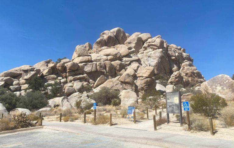
Hidden Valley Trailhead
Hidden Valley Rock Formations
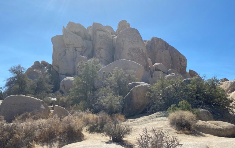
Barker Dam Trail
Barker Dam is the first right as you continue to drive south east after Hidden Valley.
One of the other easier trails in the park, Barker Dam Trail travels only in a 1.1 mile loop with very little elevation gain and no rock scrambling. The trail covers many of the highlights of the Mojave Desert. Rainfall affects the presence of water in Barker Dam, but you might be lucky if it has rained very recently.
Exhibits along the trail tell the history of Barker Dam and provide insight to the plants, animals, and people that call the desert home. Recommended duration for this walk is also 30 minutes.
Cap Rock
After Barker Damn, return back to Park Boulevard and continue south. Cap Rock is situated where the junction to the east side of the park is. This trail is an easy 0.4 mile loop with minimal elevation change. The path winds through Joshua trees, Mojave yuccas, and spectacular granite rock formations. Along the trail, there are benches to rest on and signs showing information about plants and wildlife.
There are picnic tables and and toilets near the trailhead as well.
This trail has minimal shade. If you are visiting in the summer, you should start this trail before 10am. Recommended duration for this walk is 30 minutes.
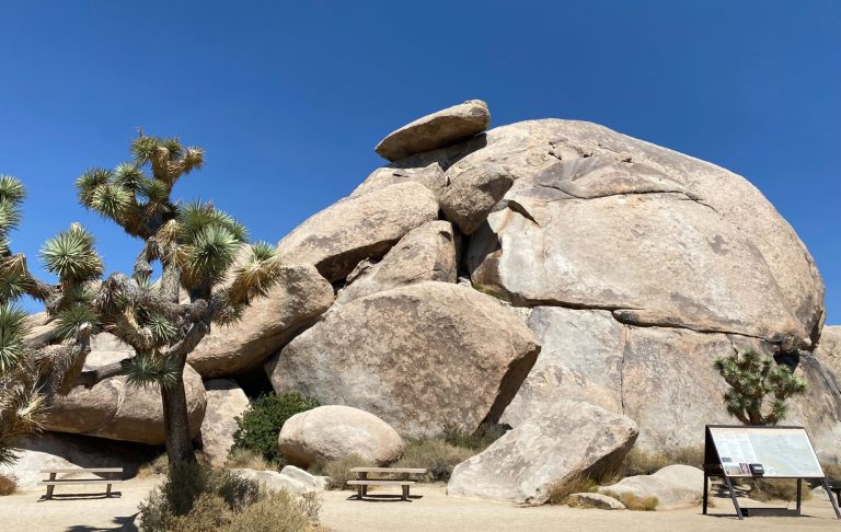
Cap Rock
Keys View
Heading south after Cap Rock, for around 6 miles, Keys View is perched on the crest of the Little San Bernardino Mountains, providing panoramic views of Coachella Valley and is well worth the 10-minute drive from Park Boulevard down Keys View Road.
Take the 0.2 mile (300 metre) short loop trail up the ridge for especially nice views across the desert. Look for the shining surface of the Salton Sea, which is 230 feet below sea level, on the far left. Looking to the right, you’ll see the Santa Rosa Mountains and Palm Springs. Further right, the usually snow-covered peak of 11,500-foot San Gorgonio Mountain is clearly visible.
The southwest side of the ridge drops nearly a mile in elevation into the Coachella Valley. The infamous San Andreas Fault, stretching 700 miles from the Gulf of California to the Mendocino Coast north of San Francisco, runs through the valley and can be seen below. On a really clear day, you might be able to see Signal Mountain in Mexico.
I’d allow 30-45 minutes for this.
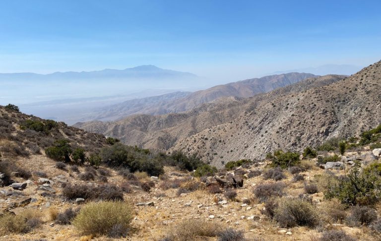
Keys View
Skull Rock
After you have had your fill of Keys View, you need to turn around and head north again. When you get back to Cap Rock, take a right to go east on Park Road, or perhaps stop for a picnic lunch (heat permitting) at the picnic area next to Cap Rock.
Skull Rock is an 8 mile (13 minute) drive from Cap Rock along Park Road. The erosion that makes the rock look like a skull began long ago when rain drops accumulated in tiny depressions and started to erode the granite. As more rock eroded, more water accumulated, leading to more erosion until, as time passed, two hollowed-out eye sockets formed and the rock began to resemble a skull.
Located about 70 feet from the road, Skull Rock is a popular stop for visitors. A parking area is located just across the road from the rock.
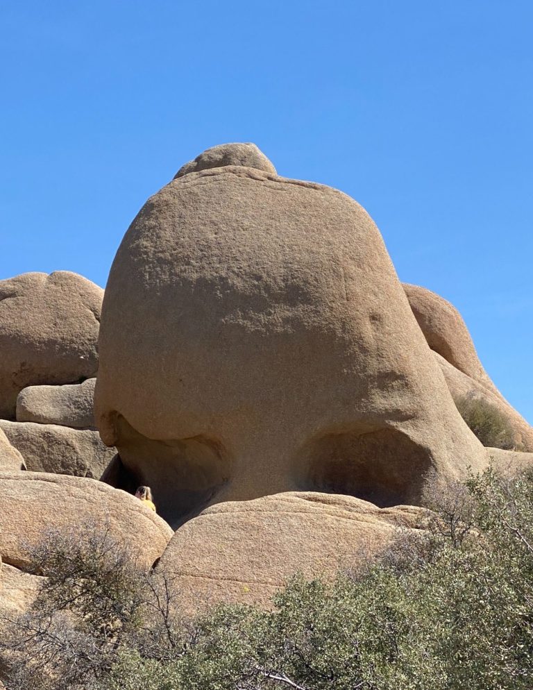
Skull Rock
Split Rock
Split Rock can be seen from the next car park which is a left turn down a track opposite Live Oak picnic area.

Split Rock
Arch Rock
After Split Rock, return to Park Road and continue east. At the end of the road turn right on to Pinto Basin Road (towards the south). The Arch Rock Trailhead is in the Twin Tanks car park, just a couple of miles down the road. The trail heads in a straight line for 0.6 miles from the car park, where it becomes a short loop. Walkers can take the loop in either direction, but walking it anticlockwise is recommended because it is easier to spot the arch from that direction. The loop is a short 0.2-miles and leads walkers back to the straight trail to the car park. Total trail length is a 1.4 mile loop.
The arch is roughly 161 metres into the loop section and is a popular photography spot. The loop also has educational signs along the trail describing the unique geology and characteristics in the area. The first part of the trail is mostly sandy, whereas the loop section is mostly rocky. This trail has no shade or mobile phone reception, and make sure you still have plenty of water. Recommended duration for this is 45 minutes.
Heart Rock
This will be very hard to find. You need to leave the Arch Rock trail onto an unmarked path. Heart Rock is north east of Arch Rock and a 15 minutes round trip back to the trail. The exact coordinates of Heart Rock are 33°59’17.6″N 116°00’47.8″W. We never found it, hopefully you will!
Cholla Cactus Garden
When you have finished at Arch Rock and (hopefully) found Heart Rock, the next stop is Cholla Cactus Gardens. This is an easy 0.25 mile walk with minimal elevation gain along Pinto Basin Road. This walk meanders through a dense patch of teddy bear cholla on the edge of the Pinto Basin and provides views of the basin and surrounding mountains. Even though this is a short and easy walk, I strongly recommend that you wear closed toe shoes for protection from the cholla. Recommended duration 30 minutes.
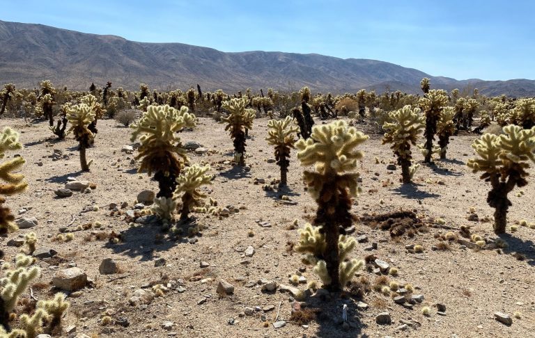
Cholla Cactus Garden
Sunset: The Best Time in Joshua Tree
Sunset is one of the most magical times to be in the park. As the sun drops lower, the desert landscape glows with warm colours, and the shadows of the rock formations stretch across the sand.
Best Sunset Spots
Some of the best sunset locations include:
- Keys View – panoramic desert sunset
- Cap Rock – classic Joshua tree silhouettes
Cap Rock is particularly popular with photographers because the rock formations create dramatic silhouettes against the sunset sky.
Depending on how quickly you completed your itinerary, you could drive back to one of the two areas above, or as the north exit to the park is a 20 mile drive north from the Cholla Cactus Garden, you could make your way towards the exit and stop pretty much anywhere to see a stunning sunset.
Sunset, depending on the time of year, is between 5pm and 8pm.
And that’s it - the best way (tried and test) way to spend a day in Joshua Tree National Park, and not feel that you have missed anything.
Is One Day in Joshua Tree Enough Though?
While you could easily spend several days exploring the park, a well-planned day allows you to see many of the highlights.
With our itinerary you’ll experience scenic desert drives, unique rock formations, easy walking trails, and incredible sunset views.
For many visitors, including us, it’s one of the most memorable stops on any California road trip.
Tips for visiting Joshua Tree National Park
The desert climate is extremely dry, and dehydration can happen quickly.
- There are no petrol (gas) stations, so make sure you have a full tank.
- There are no restaurants, grocery stores, or hotels. Bring all your own food, water, and supplies - salty snacks, sports drinks with electrolytes and something high in carbs.
- Bring more water than you think you will need - about 4 litres per person.
- Mobile phone reception is very limited, and non-existent in some areas.
- Download the Park map in advance.
- Arrive Early. Popular areas like Hidden Valley and Skull Rock can get busy quickly.
- The park can be busy on public holidays and weekends from October to May.
- Watch for Wildlife. You might spot desert tortoises, lizards, and coyotes during your visit.
- Pets are not allowed on trails. They must always be on a lead and can't be more than 100 feet from a road.
Final Thoughts on Joshua Tree National Park
With its strange Joshua trees, giant boulders, and vast open skies, Joshua Tree National Park a place that leaves a lasting impression.
Even with just one day, you can experience the park’s most iconic landscapes and enjoy everything from sunrise walks to unforgettable desert sunsets.
Whether you’re road-tripping through California, like we were, or exploring the desert for the first time, Joshua Tree is a destination that deserves a place on your travel bucket list.
We visited Joshua Tree National Park as part of a longer road trip that took in Borrego Springs, Bombay Beach, Death Valley, and Yosemite National Park.